
In honor of GIS Day, November 19, 2014, we would like to take the opportunity to celebrate the Lewis Center 2014 GIS contest winners and display their work.
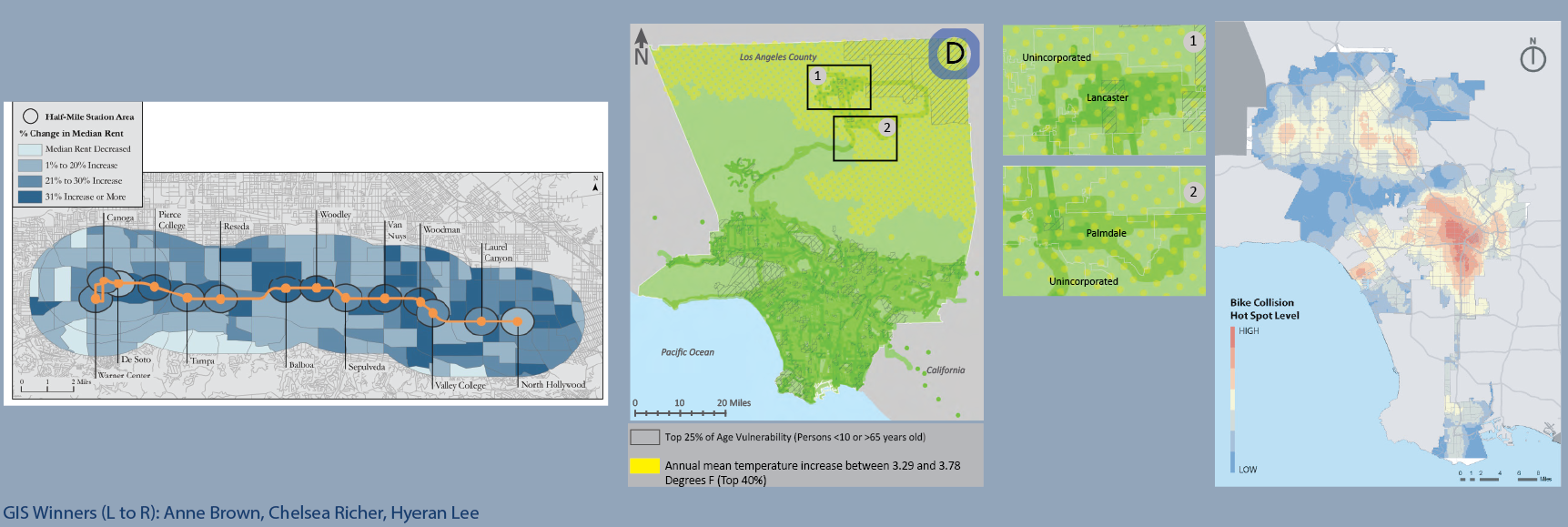
1st place: Anne Brown “Neighborhood Change Along the Orange Line”
In this project, Anne examined how the Orange Line, a full-service bus rapid transit line in Los Angeles’s San Fernando Valley, influence on the surrounding area since the line began operations in 2005. Through advanced analysis and GIS skills such as proportionally adjusting the geographic boundaries, Anne found “few significant differences between the demographic, economic, transportation and housing shifts in station and control areas between 2000 and 2012.”
For more information, please view the completed research poster.
2nd place: Chelsea Richer “Transportation and Climate Change Adaptation: A geospatial investigation of vulnerability and resilience in Los Angeles County”
Chelsea Richer took a look at “the softer side of infrastructure” when she analyzed how the spatial patterns of social vulnerability and how this vulnerability may change with the future effects of climate change. Using a large set of complex data, including CalEnviroScreen data, temperature increase, wildfire risk, flooding and sea level rise, and measures of transportation access, this project asked “how resilient are the transportation users in LA county, given population patterns, modal choice and availability, and predicted climate change effects?”
To look at the answers found in this project, please view the completed research poster.
3rd place: Hyeran Lee “Does the LA Bike Plan 2010 Serve the Right Areas?”
The final award winning project tackled analyzing collisions and neighborhood demographics and connecting their spatial patterns to future improvements in the bicycle network in the City of Los Angeles. Hyeran found collisions involving pedestrians to be more concentrated than collisions involving cyclists. In both modes, however, central LA “also the lowest income area, had the highest collision density for both pedestrians and cyclists.” After referencing these hot spots to the 2010 Los Angeles Bicycle Master Plan, she found “a spatial discrepancy in distribution of bikeways” where hot spots in Downtown Los Angeles had a lot of planned improvements, hot spots in the San Fernando Valley were covered by far fewer future bicycle improvements.
To see all of her analysis, please view the completed research poster.
The Lewis Center, represented by graduate student researcher, Emma Ren, will be presenting maps from the project “Seniors and Parks: identifying places to build parks for community elders” at the Young Research Library from 1:00 to 3:00. For more information, please visit the UCLA Library website.


